Geotechnical Investigation at Proposed MSS#13 Area – PT Vale Indonesia, Tbk
PT Geo Sinergi Utama (GeoSynergy Solution) successfully conducted a comprehensive geotechnical study at the Proposed MSS#13 Area, located in Bahodopi Block 1, Central Bungku District, Morowali, Central Sulawesi.
The work was part of the Tanamalia Project FEL-2 Geotechnical Study under Contract No. 4600082605 for PT Vale Indonesia, Tbk.
Scope of Work
The investigation covered two (2) boreholes and four (4) test pits, supported by field testing and laboratory analysis to evaluate subsurface conditions and material characteristics.
Fieldwork was carried out from 16 to 27 September 2025, with laboratory tests completed at GeoSynergy’s in-house laboratory in Kendari.
Site Conditions
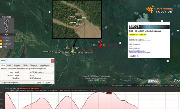
The project site features undulating to steep topography ranging between RL 483.09 and 762.30 mASL with slopes of 10–17%.
Based on the Bungku Geological Map, the boreholes are located on the boundary between the Ultramafic Complex (Cretaceous age) and Alluvium Formation (Holocene age).
Dominant materials include harzburgite, lherzolite, wehrlite, diabase, gabbro, and alternating sandstone, claystone, tuff, and conglomerate layers.
Artikel terkait: Geotechnical Consulting for Sustainable Industrial Growth
Seismic and Hydrogeological Conditions
According to the Indonesian Seismic Hazard Map (2017) and SNI 1726:2019, the site is located in a region with a Peak Ground Acceleration (PGA) of 0.5–0.6g.
The soil classification, based on NSPT data, falls within Site Class SD, with an amplification factor (FPGA) of 1.1 and a seismic coefficient (kh) of 0.275g.
Groundwater levels range between RL 793–818 mASL, showing a gradual decline over a four-day monitoring period as recorded by DipperLog™ instrumentation.
Field and Laboratory Testing
Field testing included Standard Penetration Tests (SPT), Undisturbed Sampling (UDS), and Falling Head Permeability Tests.
Permeability results ranged from low to very low, indicating minimal groundwater flow through the subsurface layers.
Key laboratory findings are summarized below:
| Parameter | Boreholes | Test Pits |
|---|---|---|
| Unit Weight (γ) | Limonite (Wet 1.61–1.71 gr/cm³; Dry 0.93–1.04 gr/cm³); Rocky Saprolite (Wet 1.48 gr/cm³) | – |
| Natural Water Content | 44.4–86.2% | 30.1–42.4% |
| Specific Gravity (SG) | 2.61–3.13 | 2.90–2.98 |
| Plasticity Index | High plastic silts (elastic silts) | – |
| Compaction (OMC / MDD) | – | OMC 30–35%; MDD 1.41–1.48 kN/m³ |
| CBR (Unsoaked) | – | 38–58% |
The subsurface profile is dominated by peridotite (≈30%), with high plasticity silty soils that may influence subgrade and slope stability conditions.
Conclusion
The geotechnical investigation at the Proposed MSS#13 Area provides essential data on soil behavior, groundwater conditions, and seismic response for PT Vale Indonesia’s Tanamalia Project.
These findings form a critical foundation for design and construction planning within Morowali’s ultramafic terrain.